


St Chely

ARPF
User
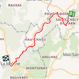

Length
11.1 km

Max alt
543 m

Uphill gradient
420 m
Km-Effort
16.8 km

Min alt
441 m

Downhill gradient
442 m
Boucle
No
Creation date :
2016-05-17 00:00:00.0
Updated on :
2016-05-17 00:00:00.0
--
Difficulty : Medium

FREE GPS app for hiking
 SityTrail
IGN / Geographical institutes
SityTrail Plus
The world is yours!
About
Trail Walking of 11.1 km to be discovered at Occitania, Lozère, Gorges du Tarn Causses. This trail is proposed by ARPF.
Description
Robert Barto
Positioning
Country:
France
Region :
Occitania
Department/Province :
Lozère
Municipality :
Gorges du Tarn Causses
Location:
Sainte-Enimie
Start:(Dec)
Start:(UTM)
530622 ; 4909314 (31T) N.
Comments